 |
 |
Related links:
|
 |  |
Trekking in the Zabaikalsky National park
|
|
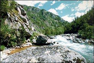
This trekking tour is a great chance for those who love adventure tourism, to see the nature of the Zabaikalsky National park, hike across the Barguzinsky range and climb up the highest mount of the Holy Nose peninsula. The nature is virgin, the rivers are crytsal pure, the views are breathtaking, the impressions are incomparable. Check our day-by-day datailed itinerary and you will see - that's the right place to go!
|
|
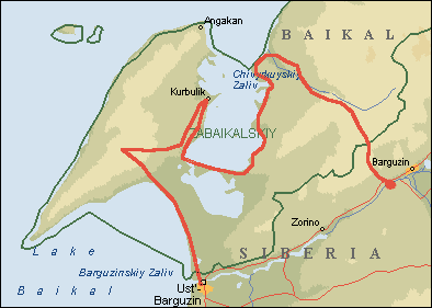
Day 1.Arrival to Ulan-Ude, transfer to hotel "Geser", city-tour. An excursion to the open-air Ethnographical museum and Buddhist temple - datsan. Lunch at the national Buryat cuisine cafe, the brief tour round the downtown.
Day 2.
Departure to Ust-Barguzin with a snack stop at Lake Baikal en route. Homestay. A meeting with representatives of Zabaikalsky National Park.
Day 3.
Breakfast with host families. Transfer by bus to the beginning of the route path. The Gremiachaya River.
The itinerary of the day presupposes light physical stress in order to get adjusted to the hiking rhythm. The trip along the path starts at 10-11 a.m. The first km of the path follows the indented country with the alternating 15 meters high ascents and descents.
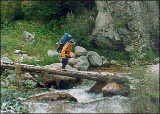
On the right side the path follows the Gremiachaya River crossing it sometimes over the laid logs. In two km a broad valley opens up on the northeastern mountainside. After it the landscape becomes more sloping. Following the northwestern direction the path crosses a lot of tributaries flowing down the mountainsides into the river. In another km the path turns to the west and following the mountainside ends at the winter quarters. With the river 30 meters to its right the winter quarters serves a good place for a night stop. The winter quarters has several simple beds for 5-6 people, a fixed trivet, and a small place for a tent camp.
The length of the path walked: 5 km
The height of climbing: 120 m
The time spent: 2 hours
Day 4.
A difficult day. The early departure is recommended. From the winter quarters the path leads to the northeast walking across the river to its right shore over the laid logs. The valley of the river is deeper and becomes narrower. The mountainsides are steep and covered with trees. The sharp cliff jags can be observed on the top of the left mountainside. The ascent gradually becomes steeper. Closer to the mountain pass the path practically disappears, thick layer of grass makes the move more difficult. The ascent to the mountain cross point is better to be done over the bottom of the valley. Though the path there is almost invisible and the air is damp still this road is better than the one done through the skimming cedar forest covering the mountainside. Closer to the top of the mountain cross the path becomes steeper coming out finally to the fine road-metal waste ground in the skimming cedar forest. There is a campsite and a trivet on the top of the mountain cross. The mountain cross with a great view upon the Barguzin River valley is a good place for taking a rest and having a snack. There is an oblong top of the mountain with two 10 and 12 meters high jags to the northeast of the mountain cross, a mountainside covered with skimming cedar to the west and the Gremiachaya River valley behind. Down from the campsite the path is very well visible. A hundred meters down the path there is a small long-awaited water spring. Some parts of the path are boggy. The top of the northeastern mountainside is another 4-meter high jag. The valley of the river is quite broad, the mountainsides are not very steep. In 4-5 km the valley falls into 3 parts. The right and the left mountainside carry two tributaries flowing into the river. The path crosses the right tributary over the logs and goes on along the right side of the main river. To the north of the tributary there is a mountain with the elevation of 1300 meters above the sea level with several jags visible on its left side. In other two km the path crosses the eastern tributary. Further on the path climbs a sloping mountainside reaching a flat territory in 50 meters distance. This may be the last point of the third day trip and a nice place for a night stop. Plenty of wood will keep you warm and picturesque cliffs will make your rest enjoyable.
The length of the path walked: 13 km
The height of climbing: 280 m to the mountain cross point plus 240 m of descent
The time spent: 5-6 hours

|
Day 5.
From the camp the path goes down the mountainside to the Dubory River flowing into the Bolshoi Chivirkuy River from the northeast. The path crosses the Dubory River over the Log Bridge. The northern side of the Dubory River valley is quite steep (20%). For the first two km the path goes along the mountainside then it moves to the left side of the Bolshoi Chivirkuy. At this side the path is broader, better stamped down and has signs. In some places the path is very narrow. The next 3 km of the path first go along the steep southern mountainside, then reach the tributary and cross it over the bridge. In another km the path comes to the place where the Markushkina River flows into the Bolshoi Chivirkuy River from the north. In the next 3 km the valley of the river becomes more slope and the path crosses one more tributary, the left one this time. A stop for a night is done on the cosy grassland located on the left shore of the Bolshoi Chivirkuy River.
The length of the path walked: 8 km
The height of climbing: 160 m descent
Time spent: 4 hours
Day 6.
The journey starts with the descent along the left shore of the Bolshoi Chivirkuy River. The right side of the valley becomes flat. In one km the left side of the valley also becomes flat. The river falls into a great number of the small rivers, the so-called "arms". The next 7 km of the path run along the sloping, sometimes boggy country and ends with the move to the right shore of the Bolshoi Chivirkuy River. Indented with numerous valleys the northern mountainside maintains its steepness till it reaches the very lake, while to the southeast of the path there is a boggy territory. In the next 5 km the path moves away from the river and goes down to a Zabaikalsky national park post Chivirkuy. On the way to the settlement one has a chance to enjoy the wild strawberries. In the settlement the group meets National park rangers and arranges the tent camp on the shore of Lake Baikal.
The length of the path walked: 11km
The height of climbing: 80 m descent
Time spent: 5 hours
Day 7.
The group goes to the sandy beaches of Krokhalinnaya Bay located to the south of Chivirkuy settlement. To reach the bay the group crosses a small mountain. In the Krokhalinnaya Bay the group is accommodated on a boat hotel "Harmony" with a sauna, nice food. Wonderful beach and catamarans.
The length of the path walked: 10 km
Time spent: 2.5 hours
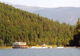
Barge hotel in Chivirkuisky Bay.
|
Day 8.
Soon after breakfast the group takes a boat to the opposite coast of the bay to visit another bay called Zmeevaya, famous for its hot springs. After a short rest at the springs the group moves to the eastern coast of Zmeevaya Bay where the recreation of the group is continued on its wonderful beaches.
The length of the path walked: 2 km
Time spent: 1 hour
Day 9.
The path is wonderful all along the route. The first two km are done along the coast of Zmeevaya Bay. Further on the path goes by the Osinovsky Cape, entering the Millionnaya Bay from the coast of which one can see Pokoiniky stone - one of the 7 islands of the bay. Then the path goes around Okunevaya Bay with quite steep bluffs all along the way. Finally the path crosses the ridge by the Pokoiniky Cape and reaches the Kurbulik settlement. Then the group is transferred by bus from Monakhovo to the Glinky place, where it stays for a night in tents.
The length of the path walked: 13 km
Time spent: 4 hours
Day 10.
After breakfast the group starts climbing the Vidovaya Mount, one of the highest peeks of the Holy Nose. The path leading to the top is quite steep. When already on the top one enjoys wonderful views of the Barguzinsky and Chivirkuisky Bays, the isthmus and Ust-Barguzin settlement. After the descent the group is transferred by bus to Ust-Barguzin settlement and accommodated in homestay. Banya and good dinner.
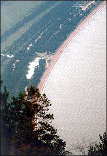
The view from Vidovaya Mount to Barguzinsky Bay
|
Day 11.
Breakfast with the local family. Transfer by bus to Ulan-Ude City. Accommodation in hotel Geser.
Day 12.
Departure.
* The increase of the speed of following the route, the reduction of staying at Lake Baikal and the change of a walking trip to a boat trip allows to reduce the continuity of the tour.
* The travelling group is provided with a guide and a ranger from the Zabaikalsky National Park.
* All gear and foodstuff is shared equally among the members of the group.
* All members of the group also take part in cooking food
* Cost per person in a group of up to 8 people is $40 per day.
We are always ready to answer any of you question about the tour, send an e-mail to us with the question you interested in and a qualified specialist will answer them.
[an error occurred while processing the directive]
|
|


